"Evacuation
Order: Immediate
threat to life. This is a lawful order to leave now. The
area is lawfully closed to public access." See
California Governor's Office of Emergency Services (here)
QWA
PROCEDURE
[IS THERE ANY
SUSPECT SMOKE, FIRE
OR EMBERS?]
SEE
SAMPLE FILLED IN FIRE INPUT AND BULLET POINT SUMMARYHERE.
(earlier version but same concept)
You
smell a fire, but don't know where it is. Cal Fire doesn't
know either.
Results
can be called into Cal Fire to help them respond to the
fire.
[it
is critical that as many stations assist so that fires can
be stopped early. Not smelling smoke is as important as
smelling smoke! ]
FORMAT
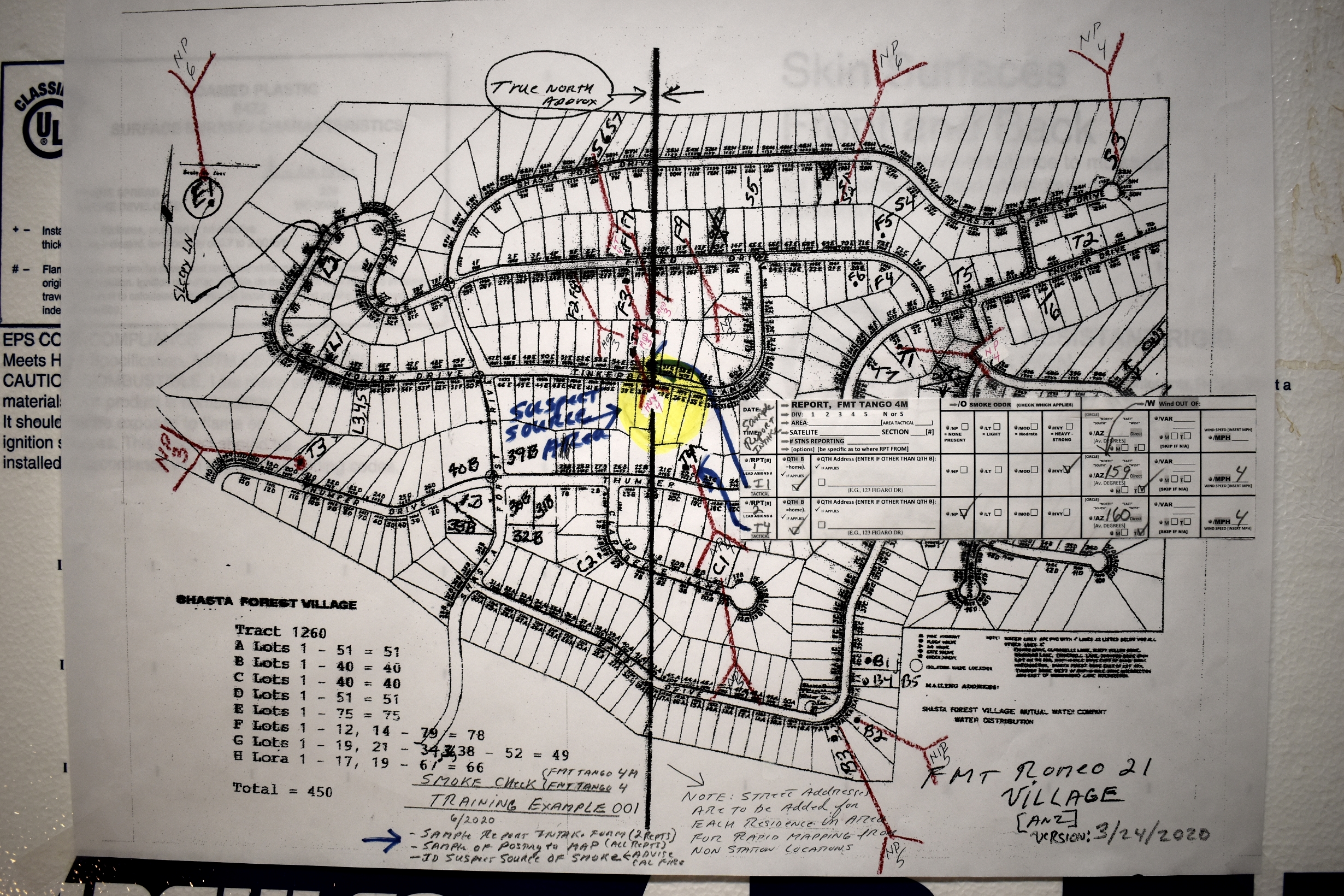
TANGO 4 SMOKE CHECK REPORT 4/09/2021
[each station makes Specific observations and records this
information on this form. Then the information is
reported into Control during the Net. The
Triangulation Station also is recording the reports but is
using Format Tango 4 Triang Map Slips (below).
Sample Report: (for Smoke Check
Net which was activated and in process)
Control says: “taking Reports” “first station go”
Response: “Bravo 1 ”
Control says: : “Bravo 1 ”
Response: "Bravo
1 REPORT FORMAT TANGO 4
DIVISION 3 NORTH; AREA VILLAGE; STNS REPORTING 2
(E.G., HUSBAND AND WIFE AT HOME);
QTH BRAVO;
NO SMOKE FIRE OR EMBERS VISIBLE;
SMOKE ODOR NONE PRESENT;
WIND OUT OF EAST, BEARING 094 DEGREES TRUE;
WIND SPEED 5 MPH;
VISIBILITY HAZE NONE PRESENT;
END REPORT - OUT”
Control says: "Copy Bravo 1 Report
#1, NEXT"
[Triangulation Station takes reports received from
Each Station and inputs the information onto this format
and uses the slips to post to Map Format Romeo 9 or your
neighborhood map]
FMT-KIL0-21-SER-DRILL-smoke
colum-Ver20200528.pdf Drill
Script - Smoke Column / Triangulation - both reporting
stations using Highway 44 mileage markers as reporting
locations.
FMT-KIL0-22-SER-DRILL-smoke
colum-Ver2020.07.09.pdf
Drill
Script - Smoke Column / Triangulation - with one station
reporting using GPS - Lat / Long as reporting location.Please
use Decimal Degrees.
DRILL
- TRAINING SMOKE CHECK VERSION DRILL #2
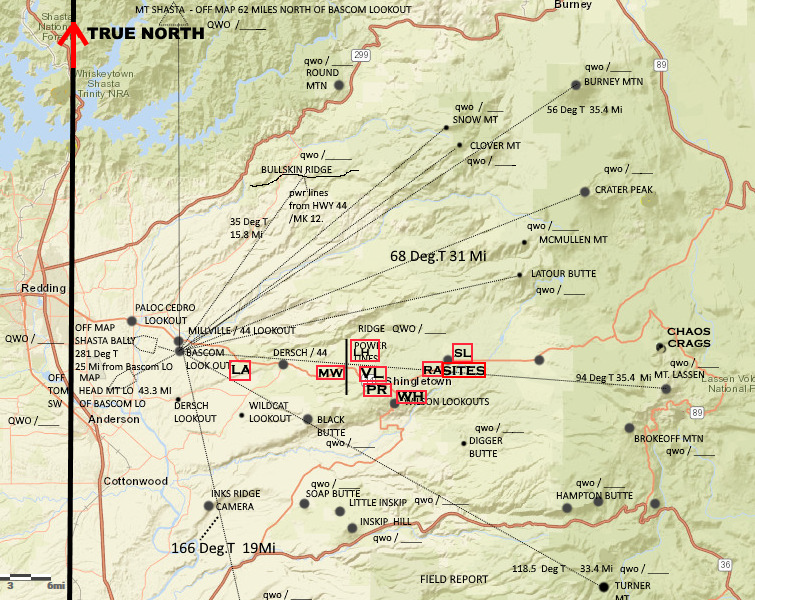
2023 02 13 - Instructions and DRILL Reports are HERE Please read the Drill Reports. Only
relevant information as set forth is to be
reported. The Triangulation Station is mapping
your reports for the purpose of determining the
originating source of the smoke. Here is the
Triangulation Station Mapping of the Report
of Village F1 and F2 onto the Village Map
(after marking the bearing - True North). The
budgeted time for each posting by Triangulation
is 10 seconds per report PHOTO
HERE The summary reports for the Village
and other AREAS would likewise be posted to the
Overall Shingletown Map (Format Romeo 9A). Analysis is
then done for the purpose of determine the source of
the suspect smoke.
The links in DRILL #2 are duplicated here for
illustrations (in PDF links do not work)::
A.
YOU ARE GIVING A REPORT FOR EACH COLUMN ON FORMAT
TANGO 4(HERE).
FORMAT
ROMEO 4[Base
station to Base station / Base station to field
locations] propagation considerations
Ham Simplex 505 -
Propagation and Map Section reference (we need more
hams, only a few hams are involved in actual emergency
communications. This table is for the purpose of showing
historical propagation).
In this short video, you can learn howto perform Hands-Only CPR - so that
you can help deliver life-saving care until
professional responders arrive. ... Hands-Only CPR
can help gain precious time for a person
experiencing a cardiac event but knowing First Aid, CPR
and howto use an AED will enable you
to provide life-saving care in a range ...
